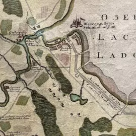
Map of the course of the Neva River from Lake Ladoga to St. Petersburg


- Pickup from gallery : Set a route
- Courier delivery
- Delivery by a transport company in the shortest possible time
- VIP air delivery
- Delivery rates
The map was compiled at the St. Petersburg Academy of Sciences. Augsburg: Printed by Georg Mattheus Seuter 1741-1742.
Map of the Neva River, from the source to the confluence of the Okhta, with adjacent parts of Karelia and Ingermanland. The map shows pubs, settlements with individual houses, including the Shabby House, Shlisselburg, Morye, Murino, Alexander Nevsky Lavra and much more. The map also shows Nevsky district and Rzhevka, the Powder towns of present-day St. Petersburg, which did not appear on the maps of the city at that time.
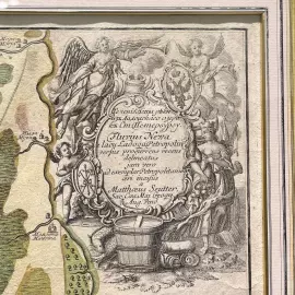
Seuter Georg Mattheus (1678-1757) was one of the greatest cartographers and the founder of the Augsburg School of Cartography. Zoiter's publishing house published many maps, atlases and globes, among which there were very few original ones.
Augsburg did not have its own university at that time, and the city had no connections with specialists in mathematics and natural sciences. Zoiter copied the works of other cartographers, making his own engravings based on their originals. In total, more than 500 maps were produced in his workshop.
His most famous works are: "Geographical Atlas or Accurate Description of the Whole World" ("Atlas Geographicus oder Accurate Vorstellung der ganzen Welt"), 1725, 46 maps; "Large Atlas" ("Grosser Atlas"), 1734, 131 maps and pocket "Atlas minor", 1744, 64 maps.
After Seuter's death, his son Albrecht Karl, son-in-law Konrad Tobias Lotter, and business partner Johann Michael Probst continued his business for the next five years.
| Brand: | Stargift |
| Material: | paper, copper, watercolor paints |
| Style: | classic |
| Sizes: | 87 × 80 × 4 cm . |

Similar products


 made of wood, to order")
 made of wood, to order")
 made of wood, to order")
 made of wood, to order")
 made of wood, to order")
 made of wood, to order")
 made of wood, to order")
 made of wood, to order")
 made of wood, to order")
 made of wood, to order")
 made of wood, to order")
 made of wood, to order")
 made of wood, to order")
 made of wood, to order")
 made of wood, to order")
 made of wood, to order")
 made of wood, to order")
 made of wood, to order")
 made of wood, to order")
 made of wood, to order")
 made of wood, to order")
 made of wood, to order")
 made of wood, to order")
 made of wood, to order")
 made of wood, to order")
 made of wood, to order")
 made of wood, to order")
 made of wood, to order")
 made of wood, to order")
 made of wood, to order")
 made of wood, to order")
 made of wood, to order")


 made of wood, to order")
 made of wood, to order")
 made of wood, to order")
 made of wood, to order")
 made of wood, to order")
 made of wood, to order")
 made of wood, to order")
 made of wood, to order")
 made of wood, to order")
 made of wood, to order")
 made of wood, to order")
 made of wood, to order")
 made of wood, to order")
 made of wood, to order")
 made of wood, to order")
 made of wood, to order")
 made of wood, to order")
 made of wood, to order")
 made of wood, to order")
 made of wood, to order")
 made of wood, to order")
 made of wood, to order")
 made of wood, to order")
 made of wood, to order")
 made of wood, to order")
 made of wood, to order")
 made of wood, to order")
 made of wood, to order")
 made of wood, to order")
 made of wood, to order")