Multi-layered wooden map "Map of Primorsky Krai No. 2, with backlight" to order
.webp)


.webp)


- Pickup from gallery : Set a route
- Courier delivery
- Delivery by a transport company in the shortest possible time
- VIP air delivery
- Delivery rates
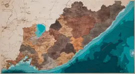
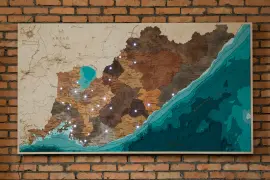
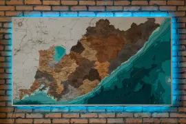
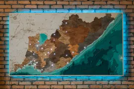
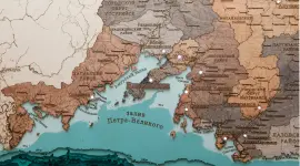
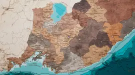
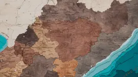
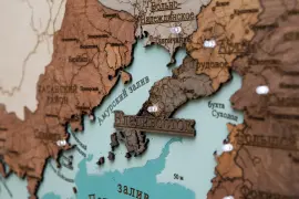
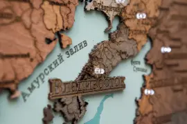
The map shows the water area of the Primorsky Territory with an indication of the large islands and the most important settlements of the region. The map shows a significant part of the settlements of the region, from larger to small villages and towns, the main rivers and lakes are also marked along with the islands of Peter the Great Bay. On the water part of the map, in addition to the signed depths, bays and bays are also marked. A feature of the map is also that all municipal districts of the region are highlighted in different colors along their borders.
Impeccable quality and exclusive design of three-dimensional paintings will not leave indifferent a true connoisseur of high-quality, environmentally friendly expensive things!
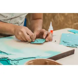
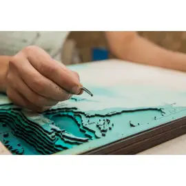
The painting is made entirely of birch bark, and each layer is painted in its own color, characterizing the depth. Minor deviations from the sample shown in the image are allowed, since the texture of the tree is unique: it is impossible to make two completely identical paintings.
This is an original and very unusual souvenir, there are no analogues of three-dimensional maps both in Russia and in most countries of the world.
You can display all aspects of your company's activities on the map, starting from the location of branches, ending with, but not limited to, the location of oil rigs, gas pipelines, telecommunications lines, ship tracks, fishing zones, mining sites, geological exploration sites and much more!
| Country of manufacture: | Russia |
| Material: | paints |
| Style: | modern |
| Sizes: | 231 × 129 cm . |
| Weight: | 61.9 kg . |

Similar products


 made of wood, to order")
 made of wood, to order")
 made of wood, to order")
 made of wood, to order")
 made of wood, to order")
 made of wood, to order")
 made of wood, to order")
 made of wood, to order")
 made of wood, to order")
 made of wood, to order")
 made of wood, to order")
 made of wood, to order")
 made of wood, to order")
 made of wood, to order")
 made of wood, to order")
 made of wood, to order")
 made of wood, to order")
 made of wood, to order")
 made of wood, to order")
 made of wood, to order")
 made of wood, to order")
 made of wood, to order")
 made of wood, to order")
 made of wood, to order")
 made of wood, to order")
 made of wood, to order")
 made of wood, to order")
 made of wood, to order")
 made of wood, to order")
 made of wood, to order")
 made of wood, to order")
 made of wood, to order")


 made of wood, to order")
 made of wood, to order")
 made of wood, to order")
 made of wood, to order")
 made of wood, to order")
 made of wood, to order")
 made of wood, to order")
 made of wood, to order")
 made of wood, to order")
 made of wood, to order")
 made of wood, to order")
 made of wood, to order")
 made of wood, to order")
 made of wood, to order")
 made of wood, to order")
 made of wood, to order")
 made of wood, to order")
 made of wood, to order")
 made of wood, to order")
 made of wood, to order")
 made of wood, to order")
 made of wood, to order")
 made of wood, to order")
 made of wood, to order")
 made of wood, to order")
 made of wood, to order")
 made of wood, to order")
 made of wood, to order")
 made of wood, to order")
 made of wood, to order")