Wooden multi-layered "Map of Africa" to order


- Pickup from gallery : Set a route
- Courier delivery
- Delivery by a transport company in the shortest possible time
- VIP air delivery
- Delivery rates
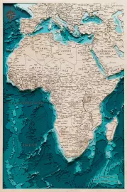
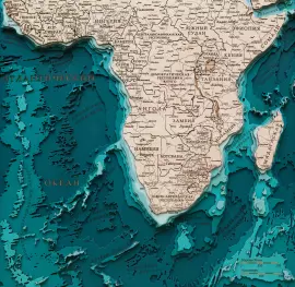
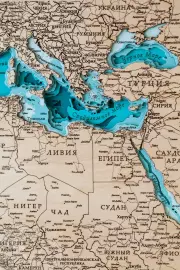
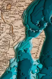
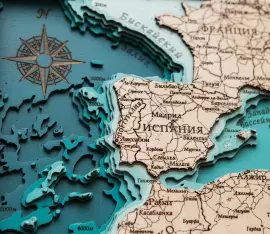
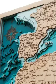
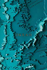
The map shows Africa, the second largest continent on the planet, occupying a fifth of the landmass. Africa is the central continent that passes through the equator and the prime meridian at the same time. The schematic image of the mainland shows the largest of the 54 countries with capitals, the island of Madagascar. There are also images of Saudi Arabia, Turkey, and some European countries with capitals. The continent is washed by the Atlantic, Indian Ocean – on the map you can see the relief, the depth marks of the ocean floor. The detailed image shows straits, seas, and underwater rock formations.
Impeccable quality and exclusive design of three-dimensional paintings will not leave indifferent a true connoisseur of high-quality, environmentally friendly expensive things!
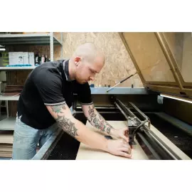
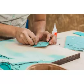
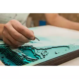
The painting is made entirely of birch bark, and each layer is painted in its own color, characterizing the depth. Minor deviations from the sample shown in the image are allowed, since the texture of the tree is unique: it is impossible to make two completely identical paintings.
This is an original and very unusual souvenir, there are no analogues of three-dimensional maps both in Russia and in most countries of the world.
You can display all aspects of your company's activities on the map, starting from the location of branches, ending with, but not limited to, the location of oil rigs, gas pipelines, telecommunications lines, ship tracks, fishing zones, mining sites, geological exploration sites and much more!
| Country of manufacture: | Russia |
| Material: | birch bark, paints |
| Style: | modern |
| Sizes: | 59 × 88.5 cm . |
| Weight: | 5.6 kg . |

Similar products


 made of wood, to order")
 made of wood, to order")
 made of wood, to order")
 made of wood, to order")
 made of wood, to order")
 made of wood, to order")
 made of wood, to order")
 made of wood, to order")
 made of wood, to order")
 made of wood, to order")
 made of wood, to order")
 made of wood, to order")
 made of wood, to order")
 made of wood, to order")
 made of wood, to order")
 made of wood, to order")
 made of wood, to order")
 made of wood, to order")
 made of wood, to order")
 made of wood, to order")
 made of wood, to order")
 made of wood, to order")
 made of wood, to order")
 made of wood, to order")
 made of wood, to order")
 made of wood, to order")
 made of wood, to order")
 made of wood, to order")
 made of wood, to order")
 made of wood, to order")
 made of wood, to order")
 made of wood, to order")


 made of wood, to order")
 made of wood, to order")
 made of wood, to order")
 made of wood, to order")
 made of wood, to order")
 made of wood, to order")
 made of wood, to order")
 made of wood, to order")
 made of wood, to order")
 made of wood, to order")
 made of wood, to order")
 made of wood, to order")
 made of wood, to order")
 made of wood, to order")
 made of wood, to order")
 made of wood, to order")
 made of wood, to order")
 made of wood, to order")
 made of wood, to order")
 made of wood, to order")
 made of wood, to order")
 made of wood, to order")
 made of wood, to order")
 made of wood, to order")
 made of wood, to order")
 made of wood, to order")
 made of wood, to order")
 made of wood, to order")
 made of wood, to order")
 made of wood, to order")